 Metadados do Visão
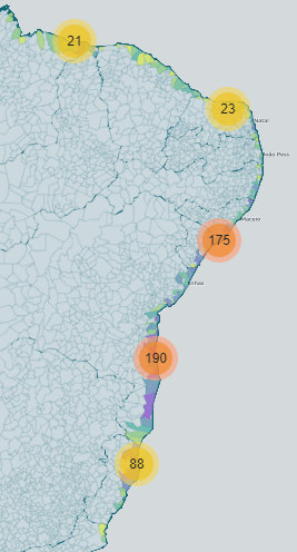
Áreas oleadas no litoral brasileiro
Mapa digital criado no âmbito do projeto visão para apresentação das áreas atingidas por óleo no litoral brasileiro, bem como os impactos ambientais causados.
Simple
Identification info
- Date (Publication)
- 2022-10
- Presentation form
- Digital map
- Credit
- Time de informação do Visão
Publisher
Instituto Brasileiro de Informação em Ciência e Tecnologia - IBICT ()
SAUS Quadra 5, Lote 6, Bloco H
Brasília
70070-912
Brasil
IBICT
>
Instituto Brasileiro de Informação em Ciência e Tecnologia
- Topic category
-
- Environment
- Economy
- Farming
Extent
N
S
E
W
))
- Keywords (Theme)
-
- Óleo
- Language
- Portuguese
Distribution Information
- OnLine resource
- Download from website
Reference System Information
- Reference system identifier
- WGS84
Metadata
- Metadata identifier
- urn:uuid/f5e818bf-e20b-4b55-8b84-e44e2aa823a0
- Language
- Portuguese
- Character encoding
- UTF8
Point of contact
Type of resource
- Resource scope
- Dataset
- Metadata linkage
- https://beta.visao.ibict.br/geonetwork/srv/api/records/f5e818bf-e20b-4b55-8b84-e44e2aa823a0
- Date info (Revision)
- 2025-01-20T17:15:11
- Date info (Creation)
- 2022-10-18T13:28:30
Metadata standard
- Title
- ISO 19115-3
Overviews
VisaoAreaOleada.PNG
Spatial extent
N
S
E
W
Provided by

Associated resources
Not available